
IMD update: Fresh depression alert as Arnab brings heavy rain to Chhattisgarh, UP, MP
IMD flags fresh low-pressure over South Andaman Sea amid Arnab remnants, forecasting heavy rains in central India and new Bay of Bengal activity.
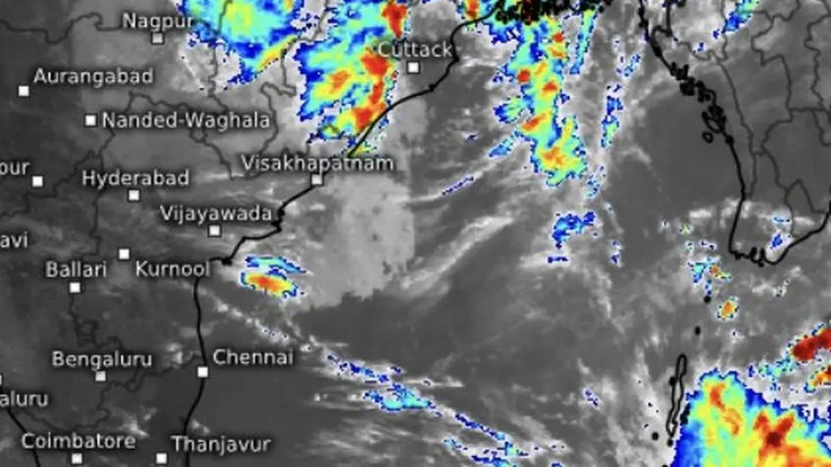
Barely two mornings after very severe cyclone Arnab made landfall, the Bay of Bengal is stirring again. The India Meteorological Department (IMD) has identified a fresh low-pressure area over the South Andaman Sea, which could intensify into a depression within the next two days as a back-to-back weather system over the basin.
The new system is taking shape even as Arnab’s remnants continue to unload rain over central India. The cyclone’s remnant circulation lay as a depression over south Chhattisgarh and adjoining south Odisha this Thursday morning, centred about 20 km west of Jagdalpur in Chhattisgarh.
Heavy rain recorded
During the 12 hours ending at 5.30 am on Thursday, Odisha, coastal Andhra Pradesh and Yanam recorded heavy to very heavy rainfall. Gopalpur in Odisha and Machilipatnam in Andhra Pradesh received 9 cm each; Balasore, Paradip Port, Tuni and Amaravati in Andhra Pradesh recorded 7 cm each. Keonjhar and Visakhapatnam received 6 cm each, while Jharsuguda recorded 5 cm.
The IMD has forecast isolated very heavy rainfall over East Uttar Pradesh on Thursday, with isolated heavy to very heavy rain likely over East Madhya Pradesh and Chhattisgarh. East Uttar Pradesh could see isolated heavy rainfall on Friday as well. The remnant depression from Arnab is expected to track nearly northwards and weaken into a well-marked low-pressure area by Thursday evening. But as Arnab’s remnants gradually lose steam over land, the Bay is already preparing for another round of activity.
Warm pool keeps Bay ticking
The speed with which a fresh ‘low’ has emerged after a very severe cyclone is noteworthy. A cyclone’s torrential rain and churning winds can stir cooler waters from below, lowering sea-surface temperatures (SSTs) and potentially making the ocean less hospitable to another storm. Cyclones generally thrive over waters warmer than about 26.5°C, although ocean heat content, atmospheric conditions and wind shear also determine whether a system can develop and intensify.
Yet satellite imagery on Thursday morning indicated a remarkably warm pool, with sea-surface temperatures around 30°C near the Andaman and Nicobar Islands and the adjoining east-central Bay. Much of the rest of the Bay remained warm at around 29°C, offering a potentially favourable source of energy for the fledgling system.
The new ‘low’ could become well marked over the South Andaman Sea on Friday as it begins to organise. Moving west-northwest towards the north Tamil Nadu–Andhra Pradesh coast, it is likely to intensify into a depression over the south-east Bay and adjoining parts of the Andaman and Nicobar Islands and the Andaman Sea by Saturday.
Positive IOD, MJO pulse
The ocean’s warmth is only part of the story. A positive Indian Ocean Dipole (+IOD) has emerged, strengthening the broader atmospheric signals over the Indian Ocean. Recent observations also point to an active Madden–Julian Oscillation (MJO) signal propagating across the basin.
The MJO is a large-scale pulse of tropical cloudiness, rainfall and atmospheric circulation that travels eastwards around the equator. Its amplitude has increased, possibly reflecting constructive interference with the strengthening +IOD. Dynamical model forecasts suggest that the signal will persist and continue eastwards towards the eastern Indian Ocean over the next fortnight.
First manifestation
Enhanced easterly winds in the upper atmosphere may be influencing this slow evolution. Model projections also indicate the possibility of the signal returning to the western hemisphere before propagating into the Indian Ocean again during the third week of November. Arnab, which formed over the Bay on October 26, may have been the first major manifestation of a favourable phase for storm development. The fresh ‘low’ now emerging in its wake could provide the next test of how long these conditions persist.
Super typhoonn In-Fa
Meanwhile, the nearby north-west continues to provide a favourable environment to host or breed cyclones (typhoons). Super typhoon In-Fa is carving a path across the open Pacific, broadly following the track of predecessor super typhoon Champi. Located about 3,500 km due east of the Philippines, In-Fa is heading towards the western Pacific, and is being tracked for sending out any incoming pulse into the Bay.
Its eventual track remains a separate forecast challenge. An early outlook points to a scenario where it could recurve more than once and weaken before reaching the East China Sea, as Champi did earlier, or turn away towards the open Pacific. Its future movement will depend on how the surrounding steering currents evolve.
Source: BusinessLine Economy
Disclaimer: This article is for general information and does not constitute investment, tax or legal advice. Markets and rates change; please verify with official sources or a qualified professional before you act.