
IMD update: TN to get more rain for 4 Days as low-pressure area brews
IMD forecasts heavy to very heavy rains across Tamil Nadu and neighboring regions this week, with a second low-pressure system possibly intensifying in the Bay of Bengal.
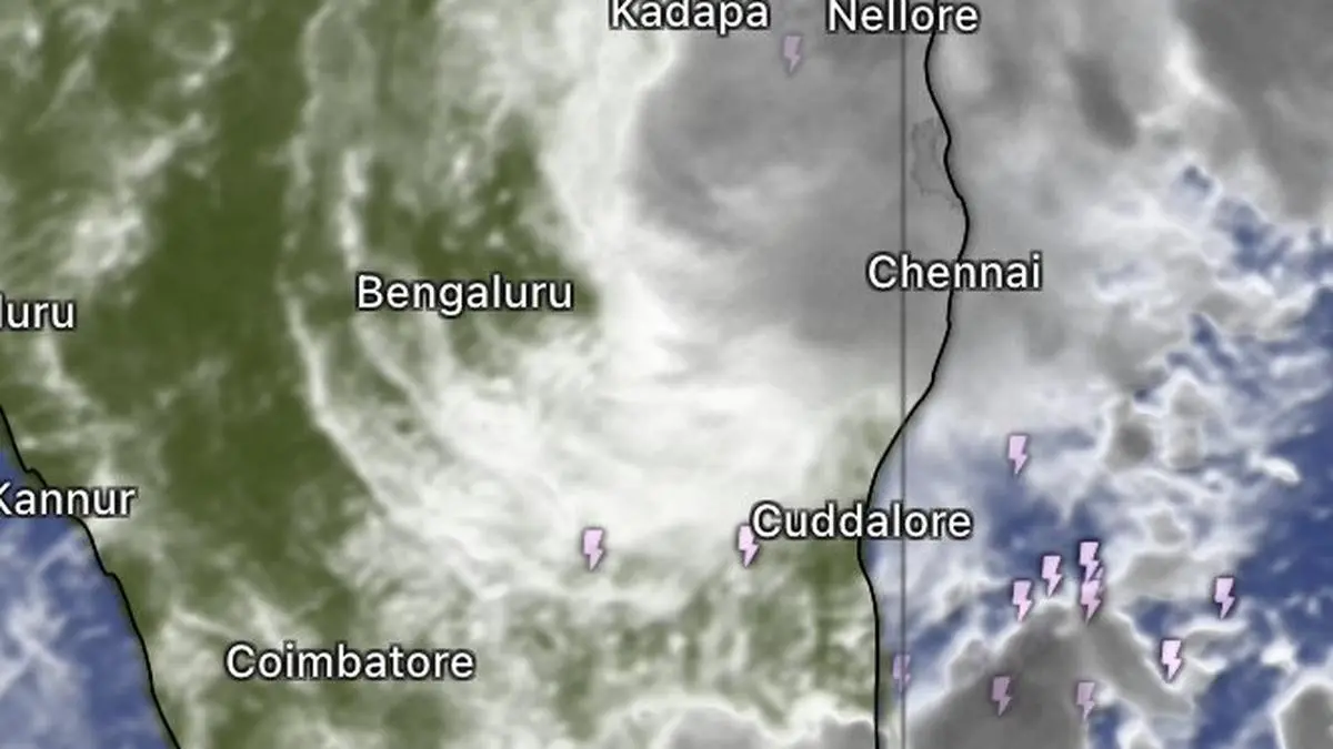
The north-east monsoon continues to be in a vigorous state over the South Peninsula, with isolated very heavy rainfall of 11.5–20 cm forecast over Tamil Nadu, Puducherry and Karaikal on Wednesday and Thursday as a cyclonic circulation over the south-west Bay of Bengal and adjoining Tamil Nadu coast prepares to consolidate into a low-pressure area by this (Wednesday) afternoon.
Sunny, humid interludes
The developing system is expected to sustain an active spell of rain over the region, while an elongated trough of lower pressure extending from the circulation towards north coastal Andhra Pradesh is helping organise clouds and showers across a broad swathe of the southern peninsula.
Chennai can expect a largely overcast day, with rain and thunderstorms giving way to a brief lull before showers return around 10 pm. The skies are likely to clear again by Thursday morning. Bengaluru, meanwhile, may remain partly cloudy, with possibility of thunderstorms between 3 pm and 8 pm before conditions improve. Sunny intervals between showers, coupled with October’s lingering heat, keep humidity levels uncomfortably high.
Stretching rain belt
India Meteorological Department (IMD) has forecast isolated heavy rainfall of 6–11 cm over Kerala and Mahe for seven days from Wednesday, and over South Interior Karnataka for four days. Tamil Nadu, Puducherry and Karaikal are likely to receive isolated heavy showers for another four days from Friday, while Lakshadweep could see similar rainfall for five days from Thursday. Coastal Karnataka is in line for isolated heavy rain on Saturday, with Coastal Andhra Pradesh, Yanam and Rayalaseema also under the heavy-rain watch on Wednesday.
Thick cloud cover
The morning cloudscape offered a glimpse of the system’s reach. At 9.15 am, a dense band of rain-bearing clouds stretched southwards from Kavali along the Andhra coast through Nellore and Gudur, extending inland towards Tirupati, Nagari and Chittoor. The belt covered parts of Coastal Andhra Pradesh and Rayalaseema, with isolated to scattered rainfall, thunderstorms and lightning likely at several places.
Further south, cloud cover extended across Vellore, Kanchipuram, Tiruvannamalai, Chennai, Cuddalore and Chidambaram, reaching inland towards Salem, Namakkal, Tiruchirappalli, Mannargudi, Palani, Dindigul and Madurai. The cloud belt extended further towards Rajapalayam, Thoothukudi and Kanyakumari, with adjoining parts of Kerala, including Thiruvananthapuram, also under extensive cloud cover. Bands of clouds spilled offshore from Chennai and the south Andhra coast into the Bay of Bengal.
Second ‘low’ over Bay
The south-east Arabian Sea was also thick with clouds, with extensive cover over the Lakshadweep Islands and adjoining waters extending northwards towards the Kerala coast off Kozhikode. The distribution points to a broad zone of unsettled weather across both sides of the South Peninsula.
Even as the first low-pressure area takes shape in the south-west Bay, attention is turning to the north Andaman Sea, where another weather system is expected to emerge. A potent circulation over the Gulf of Thailand and adjoining Myanmar is forecast to move into the north Andaman Sea by Thursday morning. It is then expected to track west-north-west over the larger Bay, bringing up a second ‘low’ over the south-east and adjoining east-central Bay by Friday.
The system could move further north-west and intensify over following three days, extending into early next week. IMD’s numerical weather prediction models continue to indicate possibility of tropical cyclone development, although its eventual intensity and track will become clearer as it evolves. If it develops as projected, it add another layer of activity to an already unsettled Bay during the north-east monsoon season.
Super typhoon Champi
Meanwhile, the western Pacific is contending with a much more powerful storm. Category 5 super typhoon Champi with wind speeds of 290 km/hr is forecast to pass dangerously close to the northern Philippines, with Taiwan to its north-west, also keenly watching its progress. The storm is expected to weaken substantially, potentially to Category 1 intensity by Sunday, as it moves past Taiwan towards the East China Sea. Its projected weakening notwithstanding, the close passage poses a significant weather threat to areas along its path.
Source: BusinessLine Economy
Disclaimer: This article is for general information and does not constitute investment, tax or legal advice. Markets and rates change; please verify with official sources or a qualified professional before you act.